Southwest
into the land of 'Ksan or the Skeena River, this
area has been travelled and used by Native peoples for over 8,000
years and continuously occupied for at least 4,000 years. The Skeena,
which provided them with food and transportation, still offers visitors
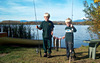
good angling oppurtunities. One of the world's most famous steelhead fishing
spots, the Kispoix River, is one of the river's major tributaries. West
towards the coast you will notice lush cedar and hemlock forests.
Moricetown: Named for Father Adrien Gabriel Morice, an explorer and Catholic
missionary, Moricetown is located on Highway 16, 32 km (20 miles) beyond
Smithers. The Wet'suwet'en people have fished this short, narrow canyon
of the Bulkley River for centuries.
New
Hazelton/South Hazelton/Hazelton (Old Town) -The
Hazeltons:
These three Hazeltons are all located very near the junction of the Bulkley
and Skeena Rivers. New and South Hazeltons were established with the building
of the Grand Trunk Pacific Railway. Both provide full services for visitors.
The Hazelton Infocentre is located at the junction of Highways 16 and
62.
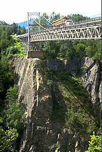
To
Hazelton (Old Town) and Kispoix/Hwy 62: Turn
north off of the Yellowhead Highway onto Highway 62 at the Infocentre
and cross the Hagwilget suspension bridge over the rushing Bulkley River
76m (250 feet) below. Visit the 'Ksan Village Museum where you can tour
long houses and view cultural exhibits.
Walking
Tour of Hazelton:
See an original steam donkey, paddle wheelers and 100 year old St. Peter's
Anglican Church.
13km (8mi)
north of Hazelton on Hwy 62 on the Kispiox Valley Road is the village
of Kispiox.
Kispiox: The traditional Gitksan village of Kispiox is located at the
junction of the Kispiox and Skeena Rivers. The Frog, Wolf and Fireweed
clans display some of their beaautiful totem poles here. Fishing camps,
guides and rafting tours are located on this exceptional steehead river.
Returning
to the Yellowhead Highway you will continue to Prince Rupert. The junction
for Hwy 37 North (the
Stewart-Cassiar Hwy) is located 42 km (26 miles) from the Hazeltons. Traveling
west you will pass the Seven Sisters Mountain Peaks, The Boulder Creek
Rest Area, Skeena River Boat Passage, Sanderson Point Rest Area, Usk Ferry
and the Kleanza Creek Provincial Park.
The
following BC Adventure Network members would like to serve you:
The following BC Adventure members would like to serve you:
Round Lake Resort: A BC Tourism Approved, Smithers, Telkwa, Bulkley Valley accommodation with lake-shore, nature trails and rustic cozy cottages on Round Lake. more